
By Lorrie Ross
Staff Writer
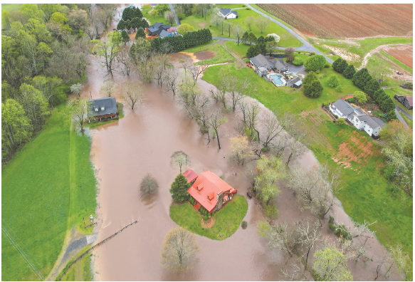
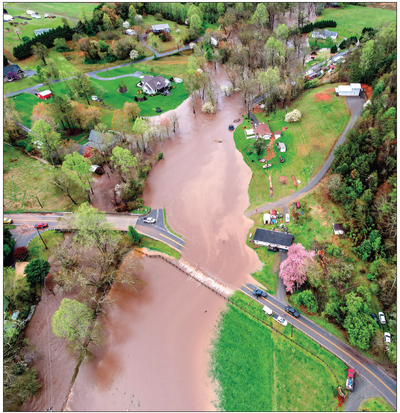
Flooded houses, roads covered with water and a washed-out bridge were part of the storm system which came to town earlier this week. After a few months of severe drought conditions, western North Carolina finally received a drenching rain Sunday and into Monday. Unfortunately, the rain came down so heavily, it created some problems around Clay County.
According to Clay County Emergency Management Director Jeff Ledford, the county had some flooded areas, which caused damage to some local homes.
“Clay County experienced significant flooding due to heavy overnight rains that began on April 6 and continued until approximately 9 a.m. today,” Ledford said Monday evening, April 7. “The rainfall caused Tusquittee and Brasstown Creeks to overflow, impacting various parts of the county.”
Ledford continued. “Approximately 25 homes have been affected, with the most severe damage reported in the lower levels of three houses,” he said. “The majority of the impacted homes are located in the Tusquittee Lane area, though damage has also been noted in Pinelog and further upstream along Tusquittee Creek.”
Ledford said the bridge on Compass Creek washed out. “Though local residents have already begun efforts to repair it,” he added. Several roads around the county had to be closed, including Julie Buckner Road, Tusquittee Creek Road and Riverbend Road.
“Emergency response teams, including local fire and rescue, the Clay County Sheriff's Office, EMS, Emergency Management, North Caroling Emergency Management and Clay County Management, collaborated effectively to address the situation and develop response plans,” Ledford explained.
He said county workers would be doing additional assessments for damage on Tuesday, April 8. “To fully evaluate the extent of the flooding impact,” he ended.
An official rain total for Clay County was unavailable, but area residents reported around three and half inches, to four inches or more. MSN Weather reported 3.68 inches for the county on Sunday and 2.9 on Monday.
At Water Resources Mission Area | U.S. Geological Survey, rainfall amounts at official rain gauges varied, with 2.65 inches at the Chattahoochee River gauge in Helen and 3.54 inches in Dahlonega. Elijay and Ball Ground, Ga., saw 4.6 inches and 4.8, respectively.
The site reported 3.67 inches in Hendersonville, while Asheville gauges showed 1.67 inches at the Swannanoa River gauge, and 1.52 inches at Biltmore. Lake Logan at the dam near Hazelwood reported 3.27 inches. These totals are for the past seven days; however, the rain was mainly during the two-day period.
When there has been a period of drought, heavy rainfall often results in more runoff. This was likely the reason for the excess flooding in a short period of time. As of Tuesday evening, April 8, the U.S. Drought Monitor had not been updated and was still showing Clay County and the surrounding area in a period of drought overall.
Typically, humidity levels in the Blue Ridge Mountain range remains moderate to high throughout the year. This provides the misty ambiance that frequently cloaks the peaks and gives the mountains their name. Precipitation is generally distributed evenly throughout the year, with little or no dry season. That provides the region with thick vegetation and abundant water sources.
The climate of the Blue Ridge Mountains may also contribute to unusual climatic events. Categorized in the lower levels as humid subtropical, the climate gradually becomes more temperate in higher elevations. These factors result in mostly mild winters and cooler summer temperatures compared to the surrounding regions. Source: https://en.climate-data.org.