
By Marcia Barnes
Staff Writer
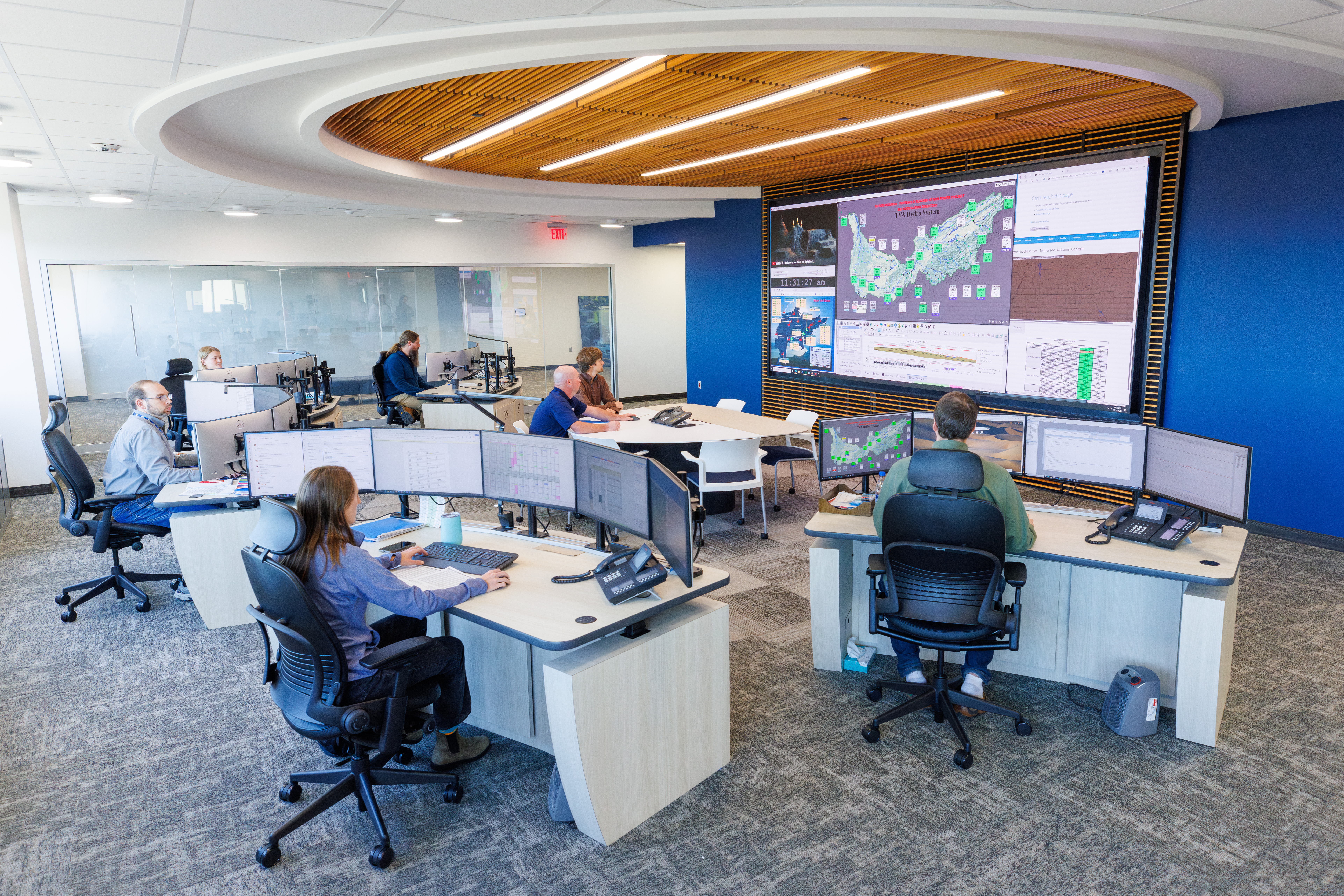
The Tennessee Valley Authority officially opened its new River Forecast Center the week of Hurricane Helene. The center located at the TVA Knoxville Office Complex was finished the Sunday before the storm and put it to the test.
“Everybody moved in that Friday, Saturday and Sunday, so Monday was the first work day in the center. Then, the storm hit Thursday, Friday and Saturday,” Scott Brooks said. “We were all in here with pizza boxes. It was all hands on deck for about four days. We were gathered around this table four days straight. We all put in 12, 14, 15-hour days.”
Past the role the center played during an unprecedented storm in the mountains, Senior Manager of the River Forecast Center Darrell Gwinn said that they like to get the word out to remind folks that the TVA is managing the rivers and how they manage the river system.
“We’re not just here to make power. There are other benefits of the river system,” Gwinn said.
“Taking a look at a few of those things, there is the Tennessee River watershed. That means if it rains within this watershed boundary, then that rainfall affects our rivers and lakes. It goes from Paducah, Ky. through western Tennessee, across north Alabama, and into east Tennessee, north Georgia, western North Carolina and a little into southwestern Virginia. Forty-one thousand square miles of area cover that watershed and on annual, the area gets about 51 inches of rainfall.
“Rain can be good, it fills these reservoirs up, it’s what we need. We can’t create the water, especially Chatuge, Nottely and Blue Ridge. These waters up in the mountains, reservoirs that are kind of the headwaters of the system, they all form the rivers that flow into Knoxville and into the river system. The main river starts in Knoxville, flows down to Chattanooga, all of the Hiawassee river system flows into the main river right above Cleveland, Tenn.”
The TVA depends on all of this rainfall. In the mountains, that water is concentrated in the reservoirs in the mountains and they are important to the system. They provide the flood protection. Water is stored in the reservoirs to protect something downstream. The dams were built to protect something downstream. Chatuge is protecting Hayesville. Chickamauga is protecting Chattanooga. When the system is added in, TVA manages 49 dams and 29 of those dams have hydro-electric facilities.
“So, you take that entire system and work it to a maximum, so you can provide a lot of flood protection using all these tributaries up in the mountains, keeping that water stored in those big reservoirs and not letting it into the Tennessee River, holding it until all that flood water has moved through the system. That’s what our goal and objective is. A lot of times in the wintertime and springtime when flood season is around, that’s our main operating objective,” Gwinn said.
In addition, the system is managing navigation on rivers, hydro-electric power generation and water supply. Municipalities all pull their water from the river system. Water quality, making the water clean is an important part of the work and managing the aquatic habitat.
Gwinn said that people come from all over the world to fish here, but it’s only possible if you manage the river system.
“You keep water flowing, you keep oxygen in the river bed. You make this aquatic habitat a place where these fish can survive, aquatic vegetation is there, the food chain is there, a big puzzle together.”
“That’s why we’re in here 24/7,” Gwinn said referring to the River Forecast Center. “All the hydro-electric facilities are remotely operated. We’re in here watching these elevations, we have real time data that comes in and tells us how high, what the elevations are, what the flows are, so we have our eyes on that. We’re able to respond to changing events and weather changes on a dime.”
The state of the art River Forecast Center also makes it possible to co-ordinate with the people who operate the units at the dams. Whatever is needed, to turn a unit on, turn a unit off.
Since the dam system was completed and closed, over $10 billion in flood damages have been averted and the reason why the TVA was created. The whole area was very deprived of economic development. If the river flooded it would wipe out communities along the river. There was poor transportation into the valley area and it was difficult. Navigation, at the time in the 1930s, 1940s and 1950s, was the main source of getting grains and goods to the communities along the river, a crucial way of getting goods from city to city.
Navigation remains an important part of the work on the rivers. You can navigate from the Tennessee River to the Gulf of Mexico. A barge can go from Knoxville to Houston.
“Take north Alabama, around Huntsville where there’s a lot of rocket industry, Department of Defense, you can’t really ship rockets down the highway. So, they come by barge when they’re built. They go down to the gulf to Houston, Florida, close to the launch,” Gwinn said.
In the River Forecast Center somebody is on staff 24/7, continually looking at updated forecasts, current conditions, weather conditions and making adjustments to those conditions in order to maximize the benefits of the system.
“If it doesn’t rain and we thought it was going to rain, we’ll hold the water to make sure we can use it when we need it. We get our weather forecasts from the National Weather Service,” Gwinn said.
TVA’s Water Source Engineers are looking at temperatures and load forecasts. They are focused on the quantity of rainfall. They want to know how much it’s going to rain, even if there’s a 50 percent chance, they want to be prepared.
Lakes, rivers and tail-water tributaries have year-round roles in recreation within the Tennessee Valley. The River Forecast Center schedules and publishes releases for white-water rafters, they furnish an app and website if people are interested in knowing what the releases are from a particular dam. They can find out what the schedule is going to be, what the releases have been, what the elevation is and what it’s expected to be over the next couple of days.
“Water is powerful,” Gwinn said. It’s a safety aspect to know what to expect.” Exploring the TVA website: tva.com/environment/lake-levels/chatuge, data is provided on the elevation of the Chatuge reservoir, the midnight headwater elevations, cubic feet per second when spilling occurs and the average hourly discharge.
In the River Forecast Center a large screen provides situational awareness. The big screen provides real time data for everybody. The number in the top box is the elevation, water elevation above sea level. The bottom number is on the downstream side of the dam, the tail-water. The middle number is how much flow is going through the turbine. If it’s green, they’re generating electric power. If it’s white, it’s off. If the numbers are in blue, they’re spilling water.
The TVA is unique in that there is no one else in the country that manages a river system the way they do. There are nine reservoirs on the main stem that make up the Tennessee River. Those elevations don’t change as much because they are the navigation channels. Tributary reservoirs, like Chatuge, can change by 20 feet or so. The tributary dams are TVA’s storage system.
“If we didn’t have a system of tributary reservoirs we’d be in trouble when the snow melts off the mountains and rain falls in March, April and May. May 2025 was the third wettest May on record and that accounted for more spilling this year,” Gwinn said.
As the largest public power provider in the United States, TVA is also the third largest electricity generator in the nation. They have the ability to pull power off the grid and keep everything balanced, balancing the supply and the demand.
When Hurricane Helene put the River Forecast Center to the test, the new space made it possible to see all current operations going on. Initially, the epic storm was forecast for the Chattanooga area and north Alabama, but that was seven to eight days out. Three days out from the hurricane, it started drifting east.
“The French Broad River starts in Asheville and that water was coming into our Douglas Reservoir. Kentucky Reservoir was the flood of records. Douglas was the relief of records,” Gwinn said. “We coordinated at the time with the Army Corps of Engineers for releases out of the Cumberland River to make sure we were not dumping too much water into the Ohio and Mississippi.”
For the people and their rivers, this was mission control center. During the worst of it, the center was able to be in communication with government relations and had the ability to speed up their approval system. If they needed to put out a social media post, all they had to do was talk to everyone who was in the room.