
By Marcia Barnes
Staff Writer
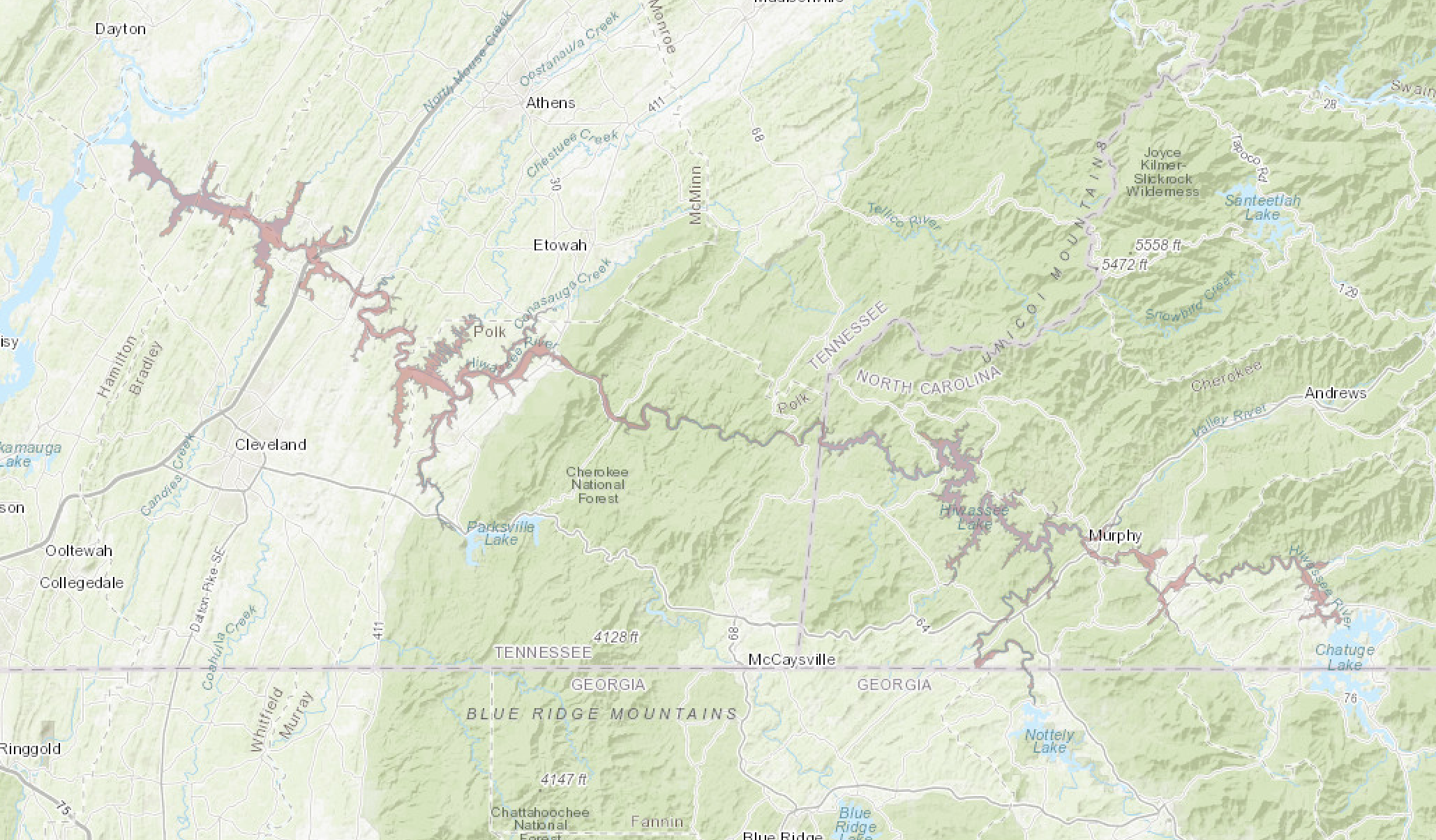
As Chatuge Dam safety modifications are under review to address concerns at the spillway, the Tennessee Valley Authority has created an interactive inundation map at: tva.com/Chatuge that shows where flooding would occur in the very unlikely event of a failure at the spillway.
On Friday, Jan. 16, TVA announced an update to the project and said that postcards are being mailed to people with interests downstream and they include a QR code to take recipients directly to the map.
The Chatuge Dam Safety Modification Study reported in spring 2024, was initiated by TVA due to concerns about the spillway at Chatuge. If a large volume of water flowed quickly over the spillway during an extreme rainfall event, that water could lift the concrete slabs. Once a slab is lifted, ground exposed to the force of the water could erode the spillway all the way back until it breaches the reservoir. Breaching means a failure of the dam to hold back the water.
The map outlines the inundation zone and shows the approximate area that would be under water in the unlikely event of a failure of the dam to hold back the water. It does not show the water depth or speed of flow during a failure.
The update from TVA states that it is important to note that flooding would likely already be ongoing near these areas, as it would take an extreme amount of rain to put the spillway in danger of failure. The update also states that it is important to remember that the inundation map represents TVA’s best approximation of a very complex scenario. The exact flood outline would likely vary to some degree from the estimates.
In the on-line video of Chris Saucier, TVA Dam Safety Senior Project Manager explains that the release of the map shows areas that could be inundated.
“I first want to emphasis that this is a rare event, not a 100-year-event or 500-year-event, it’s a magnitude higher, a very rare event,” Saucier said. “We like to act in dam safety out of caution for preservation of human life and minimization of impacts to property and damage of that sort. So, it’s pretty normal for agencies in periods where there is a heightened risk, and we are aware that the spillway at Chatuge is not really in our tolerances for risk and where we’d like it to be. In those conditions, dam owners as a standard practice reach out to the public and help inform the public about public safety measures like evacuation routes and evacuation protocols, and inundation maps like these are one piece of the puzzle.”
Saucier said that in the meantime, they do have protocols in place, interim measures, increased inspections, joint inspections, repairs and things that allow the TVA to operate the spillway safely.
“All this is really about just informing and keeping you aware, so that you can make your own plans in the event that this very rare event were to occur and you would receive some evacuation notice from your county agencies.”
In the video Saucier goes to the map, shares his screen and shows viewers the graphics and the area at-risk of flooding. The map shows Chatuge Lake, Nottely Lake, Hiawassee Lake. The pinkish-colored area on the map is the area which TVA associates with inundation from a breach of the spillway at Chatuge. There is a link at the bottom of the page which brings up the interactive page. The pinkish area starts at Chatuge Dam spillway and is the outlined area of the inundation zone.
Saucier said that basically it shows the outline of the area which would have water on it, and it is pretty approximate, and these are typically used for planning purposes. We hope individuals and families figure out their plans for where they could go and what routes are available to get out if this were to happen. Saucier said that it’s not exactly precise, it’s the best we can do.
“It’s just the outline of the area so it doesn’t show the water depth either, it doesn’t show how fast the water is flowing in that area, all that it shows is the area affected by flooding, meaning there’s some water on the property, on the ground. It starts at the dam, continues down the Hiawassee River, as it comes into Murphy the water would actually be backing up toward Nottely Lake. As I mentioned, this is a rare event, there’s a lot of water on the ground when this is happening. This is a flood event that TVA is managing and we’ve assumed that a spillway breach happens during a flood event and so there’s a lot of water that’s attempting to get out of the system. When we release a big amount of water from this potential failure it starts to back up water in other parts of the system.”
If the spillway were to fail, TVA estimates the flow into the river would reach approximately 250,000 cubic feet per second. When the Chatuge Dam is in normal hydrogeneration status, approximately 1,500 cubic feet per second is released.
“You can imagine it would be a pretty fast release, so it might reach the town of Hayesville in certainly less than an hour and would be making it’s way quickly through the system if it were to happen,” Saucier said.
In a very rare event this scenario would affect Clay County and Cherokee County in N.C., and Polk County and McMinn County, Tenn. The inundation map is being provided to help residents stay informed. Saucier said that TVA works very closely with the emergency management agencies in those counties and they will have this map also, in addition to a huge binder that is an emergency action plan that is associated with Chatuge Dam specifically and it’s spillway.
“They will be the ones that actually call for the evacuations,” Saucier said. “The local emergency management agencies in Clay, Cherokee, Polk and McMinn counties will call for these evacuations and they may use a suite of systems to make those alerts through television, radio, messages to your cell phone, and other capabilities that they have.
“That’s how this gets used and really, we’re releasing it because it’s the standard protocol and we want to make sure we’re doing what we can do to do our part to preserve human life and minimize damage for this rare possibility. Finally, just because we said we would. There are some folks who asked to see this. We agreed and so here we are wanting to meet the commitments we made to the folks we serve.”
The map has a disclaimer about the accuracy of the map. That is because it’s a planning tool. TVA views the map as a helpful tool to people in the area to understand what could happen and what they might need to do.
Saucier said that the real messages are to be prepared, look at this map and figure out what it’s going to mean for you. If you feel you’re in an area that could be affected, set up some plans ahead of time for you and your family to get out, meeting places where you meet together, and where to go, and your route to get there. If you need special assistance, make sure that you have those arrangements in place.
“I think it’s important to know that because this is happening during a major flood, it’s important to be weather aware. If there’s heavy rainfall events, those are just times of heightened awareness that we encourage you to take into your daily practices, to be informed about what this could mean for you.”
Information at the TVA website: tva.com/Chatuge, including the map give details about the inundation zone. Saucier said that it’s important to remember that local county agencies have this information and if you have any questions to call them.